It's day three of our trip to Pakistan, and we will travel on the highest paved road, also referred to as the eighth wonder of the world- the Karakoram Highway in Northern Pakistan.
We had the opportunity to witness some amazing sights, which we would like to share with you. This post will narrate our journey and experience while traveling north and returning to Islamabad. Additionally, we will provide more details about the Karakoram Highway towards the end of this article.
1. Travel from Besham to Gilgit on the Karakoram Highway (Day 3 of our trip to Pakistan)
We woke up early today, and the Besham Hilton Hotel kitchen staff were still preparing breakfast.
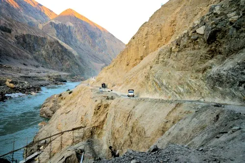
Our plan for today is to travel on the famous Karakoram Highway. The journey will take a whole day, but we are excited because we have heard that the scenery along the way is jaw-dropping. The highway was built chiefly along the Indus River.

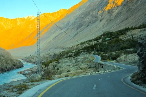
The highway winds through towering mountains with no vegetation in sight. At other times, we have found ourselves surrounded by low-altitude mountains covered in trees, with a river and mountains in the background that make us feel like we are in Switzerland. Another stretch leads to snow-capped mountains.

Despite being called a "highway," it often hugged cliffs with deep ravines below. Some stretches were so narrow that our driver had to stop and let oncoming cars pass before continuing. We even experienced rockfalls that blocked half of the road.

The drive along the Karakoram Highway was one of the main reasons for visiting this part of Pakistan, and it did not disappoint me.

On the way to Gilgit
We spent most of our day driving on a long highway to reach Gilgit. Though the Karakoram mountain ranges were mostly bare of trees and grass, they had a unique shape and beauty that made them incredibly attractive. If you believe a mountain can only be considered beautiful if covered in pine trees and snow, the stunning images we captured along the way will change your mind. The scenery was so magnificent that we had our driver stop multiple times to take photographs.
Watch the video we shot while we traveled along the Karakoram Highway at the end of this article 👇👇.
No wonder the Karakoram Highway is named the 8th wonder of the world.

We also saw animals like cows and yaks on our journey.

The journey was difficult, and some of us were not accustomed to it, resulting in travel sickness.

As we travel along the highway, we come across a junction that leads to Fairy Meadows. Unfortunately, our trip does not include visiting Fairy Meadows, but I understand why. The road leading to Fairy Meadows is considered one of the world's top 10 most dangerous roads, with sharp turns and uneven road conditions.

Elaborately decorated trucks at Dassu
We also encountered some areas where construction work and blasting were carried out, leading to temporary road closures for over an hour. While waiting for the highway to reopen, we took the opportunity to explore the surroundings and came across some exquisitely decorated trucks that captured our attention. The drivers were gracious enough to let us take some photos with them.


Some vendors are selling sand-roasted corn, which reminded me of a similar delicacy we had tried on our journey from Katmandu to Pokhara in Nepal years ago.

Several stores also sell snacks and milk tea, although we didn't try them.

The Karakoram Highway is rightfully named as one of the 8 Wonders of the World. During our journey, we captured numerous photographs and video clips, and I have selected the best ones to showcase the breathtaking beauty of the highway.
Rock Carving
We stopped by the Thalpan Das Rock Carving, which the people of Ghandaran carved during the second century.

This site is located near Chilās and has thousands of rock carvings. We chose to view the ones that are easily accessible from the highway, many of which are related to Buddhism and feature images of Buddha.

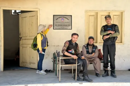
After that, we stopped at checkpoints during our trip, where the police allowed us to take photos.
We had our lunch at Chilās Shangrila Hotel, where we will spend a night during our return trip. Then, we were greeted by the breathtaking view of the Karakoram mountains during the golden hour.

We were thrilled to view Nanga Parbat, the 9th highest mountain on earth, from the Karakoram Highway.
Later in the night, we checked in to the Gilgit Serena Hotel, where our room had a king-size double bed and all the necessary facilities.
Our tour organizer arranged for us a delicious buffet, and we were well-fed.
The hotel's garden was beautiful, illuminated with lights at night. We took the opportunity to take some beautiful photographs after dinner.

2. Travel from Chilās to Abottabbad on Karakoram Highway (Day 10 of our Pakistan trip)
We returned to Abottabbad from Chilās along the Karakoram Highway on the tenth day. Putting everything we saw on these two days into one video is more appropriate. Let’s continue this video on day 10 of our return trip on the Karakoram Highway. We spent a night on day 10 at Chilās Shangrila Hotel.
After visiting Gilgit, Hunza, and Skardu, we were returning using the same highway to Chilās.
We spent the night at the Chilās Shangrila Hotel, located on the edge of the Indus River. The hotel's beautiful garden caught our attention, but what we found most impressive was its typical Pakistani village-style decoration.

I particularly liked the lock and the latch on our room's door.
We started our journey very early, at around 4:15 AM the following day. The early start is to avoid the road closure at Dassu.
Shatial Rock Carving
We followed the Karakoram Highway and soon arrived at Shatial. Our local guide, Ali, informed us that a dam is under construction here, which would eventually result in the riverbank being submerged in water.

Many houses were built along the river, but most were unoccupied. He explained that the owners had built them intentionally and would receive compensation from the government once the houses were submerged. Although it seemed like a questionable way to make money, it is the reality of the situation.

At Shatial, rock carvings are a significant archaeological site and a heritage of the Silk Road. Over 1,000 inscriptions and 700 petroglyphs can be found at the Shatial Bridge on the Indus River. More than 550 inscriptions dating from the 3rd to the 7th centuries can be identified, which were left by Iranian merchants in the Sogdian language. The rocks at Shatial also contain ancient Brahmi and Kharosthi language scripts and graffiti, indicating that the site also served as a Buddhist shrine.
Unfortunately, the Indus River dam will soon submerge the rock carvings of Shatial.
Sumer Nala
We stopped at Sumer Nala for a quick break during our trip. A few of us grabbed a cup of milk tea at the nearby store while our travel companion, Lily, took the opportunity to meditate facing the waterfall. The rest of us went for a stroll, enjoying the stunning waterfall and the gorgeous nature.

Dassu
We finally arrived at Dassu, but unfortunately, the road was still closed due to construction and explosions. It was still early, so Lily took the lead and started picking up as much trash as possible along the roadside, and soon Mary, Michelle, and we joined in.


A local gentleman with kids thanked us for our effort and helped us collect more rubbish. After we finished, he agreed to dispose of it in an appropriate place. We hope our small act of being environmentally friendly will inspire others to do the same.
Once the highway opened again, we continued our journey to Abbottabad.
Karakoram Highway Monument

We arrived at the Karakoram Highway Monument. This marks the original starting point of the 868 km-long Pakistan Section of the Karakoram Highway, which the Frontier Work Organisation built.

The monument is located near the Indus River, providing a stunning river view. It's also where three major mountain ranges meet - the Hindu Kush, the Himalayas, and the Karakoram mountain range.
Thakot
We pass through Thakot, where the locals purchase necessary items for their families. The small town was bustling with activity, and we even experienced traffic jams.

Many shops lacked windows and walls and sold only a few items. Seeing this, it was clear that poverty was a real issue for these people, and we sympathized with their difficult living conditions.

We arrived at Hotel One Abbottabad after our tiring journey.
We spend a night and will return to Islamabad, the capital of Pakistan, the following day.
Here's our story of the Karakoram Highway. We hope you enjoy this video. We will upload the next story, covering our experiences in Gilgit, Hunza, and Skardu. Stay tuned!
3. Additional information: Facts about the Karakoram Highway
- The Pakistani section of the Karakoram Highway starts at Hasan Abdal, approximately 50 kilometers northwest of Rawalpindi. The highway goes through the provinces of Khyber Pakhtunkhwa and Gilgit-Baltistan and ends at the Khunjerab Pass, which is situated on the Pakistan and Chinese border. The highway's highest point is at Khunjerab Pass, which is 4,714 meters (15,466 feet) above sea level, which can cause discomfort in some people due to the high altitude.
- The Karakoram Highway is also known as the China-Pakistan Friendship Highway. It was jointly built by the Pakistani and Chinese governments, starting in 1962 and completing in 1978. The highway extends from Hassan Abdal in the Punjab province of Pakistan to the Khunjerab Pass in Gilgit-Baltistan, crossing into western China and ending in China's Xinjiang province. In Pakistan, the highway is officially known as N-35, while in China, it is called China National Highway 314 (G314).
- The Khunjerab Pass is the highest border crossing in the world. According to Britannica and Wikipedia, the total length of the Pakistan section of the Karakoram Highway is approximately 887 kilometers (551 miles). The highway is famous for some of the world's highest peaks, including K2 and Nanga Parbat1, and offers breathtaking views of these peaks and other stunning landscapes, such as the Hunza Valley and Karakul Lake. The highway passes through many small towns and villages with unique cultures and traditions. The upcoming articles will provide more information on our interaction with the locals.
- The Karakoram Highway is also home to diverse wildlife, including snow leopards, ibex, and Marco Polo sheep. Although we did not see the leopards and sheep, some of us managed to take a photograph of the ibex.
- We will cover other historical places and viewpoints along this highway in published articles. These places include Baltit Fort, the nomads at Hunza River, and Attabad Lake.
Watch the video we shot while we traveled along the Karakoram Highway 👇👇.
Note: I have written several articles about our trip to Northern Pakistan. To read our stories, please click here.
Our trip was organized by Go Holiday 360 Sdn Bhd. Please contact them for further inquiries.

